The Initiative on Coastal Adaptation and Resilience (iCAR) has passed a milestone in its project to identify climate vulnerabilities in local communities. After six months of production, professors Barnali Dixon and Rebecca Johns have launched an interactive platform that allows citizens from across St. Petersburg to track and monitor the impacts of climate change in their neighborhoods.
iCAR’s Community Resiliency Information System (CRIS) was awarded a $50,000 grant through AT&T’s Climate Resiliency Community Challenge in February 2020. USF’s St. Petersburg campus was one of five institutions in the southeastern United States to receive the grant.
Designed to “make smart cities smarter,” CRIS uses citizen engagement and crowdsourced data to gain insights on the local consequences of climate change. The system allows residents to input data related to issues such as flooding and power outages, which can then be used by policy makers and neighborhood leaders to make decisions about policy and resource allocation. The data also allows emergency managers to identify areas with concentrations of people who need transportation assistance or are reliant on power for medical needs.
“Our goal with CRIS is to gather information and intelligence from the people,” said Dixon, executive director of iCAR and professor of geographic information systems and remote sensing. “Residents know more about their own neighborhood than anyone else. Using CRIS, we can harvest information to build a system that offers two-way communication between community members and policymakers. That way, policymakers are not just handing out policies – they’re able to cultivate information and resources from the community they intend to benefit.”
This summer, Dixon and Johns, associate professor of geography and iCAR’s director of community outreach and education, tested a preliminary platform guided by community input. Local feedback was used to refine the system, enabling the iCAR team to roll out the platform to community members in August.
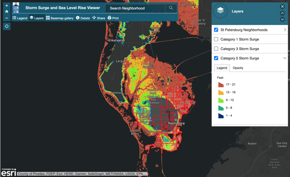
CRIS includes four core modules that offer interactive maps through which users can explore predicted impacts of environmental hazards on neighborhoods across the city. Those modules include:
- A biophysical module depicting the impact of hurricane storm surge and sea level rise.
- A socioeconomic module with information about the vulnerabilities neighborhoods face as a result of climate impacts.
- An environmental module detailing the risk neighborhood’s face to hazards in the context of the EPA’s environmental justice index.
- A hydrological and weather module that includes data collected from air quality and weather sensors.
iCAR has partnered with telecommunications company Spectrum to provide air quality and weather sensors, and with the City of St. Petersburg to help promote CRIS to the community at large.
Dixon, Johns and their team will continue collecting and analyzing data through the iCAR 2020 Workshop, which is scheduled to take place virtually on November 12 and 13. The workshop will explore ways technology can be used to examine, understand, communicate and address the problem of climate change, particularly as it relates to equity issues in resiliency planning. Following the event, the researchers will present their recommendations to officials from the City of St. Petersburg.
“Technology is a tool that can help us identify, investigate, communicate and find solutions for climate related problems while fostering resilience,” said Johns. “The power and role of technology became even more obvious during the pandemic. But socioeconomic marginalization can distance some communities from the benefits of technological tools and solutions being developed to increase resiliency.”
AT&T’s Climate Resiliency Community Challenge was launched to address resilience in the face of extreme weather and climate change. The proposals were selected through an application process that included a review by a panel of climate and resilience experts from groups like the Center for Climate and Energy Solutions and the World Wildlife Fund.
“Last year, we shared with the public the rich climate datasets that we’re using in our own risk analysis so that others can assess their vulnerability,” Andrea Brands, director of corporate social responsibility at AT&T, said at the time. “We’re now making funding available to the University of South Florida St. Petersburg campus and four other universities so they can launch innovative research on climate impacts and community responses. The universities will work with local governments to conduct climate risk analysis and help boost community resilience.”