Abstract
Design and Development of a Near Real-Time Community Crowdsourced Resilience Information System for Enhancing Community Resilience in the Face of Flooding and other Extreme Events

PIs: Barnali Dixon, iCAR – USF, Subhro Guhathakurta, Center for Spatial Planning Analytics and Visualization, Ga Tech, Yi Qiang, USF, School of Geosciences, Peng Chen, Ga Tech, College of Computing
ABSTRACT
Communities along the coast are increasingly vulnerable to coastal hazards such as flooding due to extreme weather events and sea level rise. In the US alone, 40% of the population lives in coastal cities and subjected to elevated risks of such hazards. The probability of a flooding event in these communities is also increasing with global warming. The proposed project will design a neighborhood-scale Community Resilience Information System (CRIS-HAZARD) by leveraging citizen science and community participation for enabling real-time data-driven decision-making to make communities more resilient to flooding. CRIS-HAZARD will support frequent bi-directional flow of information among communities, research scientists, and decision-makers. The objective is to develop a platform that facilitates the smart and connected city framework by engaging diverse communities to improve the lives of all citizens, especially those who are marginalized. The project is piloted in Pinellas County, Florida, in the Tampa Bay region on the Gulf Coast of west-central Florida. This region’s geography and low elevation make it especially vulnerable to climate change-induced extreme weather events like flooding.
Unlike previous attempts at integrating data and models to predict flooding events, the approach of CRIS-HAZARD is distinctive as this research pioneers the integration of user-supplied data (crowd-sourced and social media) with real-time flood prediction models and uncertainty analysis techniques, which is expected to advance our understanding of risk and resilience in coastal communities facing persistent flooding events. The initiative integrates the expertise of research institutions, government agencies (Office of Emergency Management or OEM), local stakeholders, and community engagement networks to enhance community-based planning and policy decisions, promoting community resilience. Furthermore, the project fosters customized resiliency planning at the neighborhood level engaging citizen scientists as partners. It aligns with the National Science Foundation's mission to provide transparent and accessible information on risks and vulnerability, contributing to the development of smart and resilient communities nationwide.
Funded by NSF Smart and Connected Communities: NSF Award Number:2325631
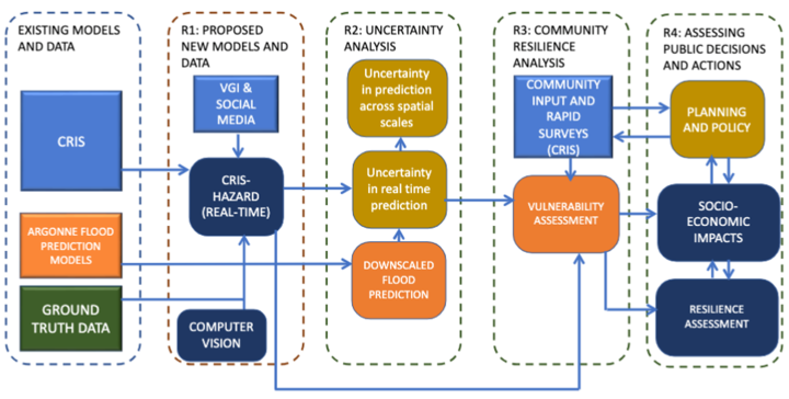
Figure 1: A Schematic Showing the Integration of Research Themes